By: The Scribe on Sunday, June 17, 2007

Archaeologists working in the Shimonogo ruins of Western Japan’s Moriyama, about 200 miles from Tokyo, uncovered what is believed to be a piece of the world’s oldest melon! Radiocarbon analysis dated the melon to around 2,100 years old, making it the oldest piece of melon found with fruit on the rind – a very rare find.
It is thought that the melon flesh was preserved due to where the fruit was located in the ruins, which was about one meter underground in a moisture-rich soil that seems to have acted like a vacuum-sealing. Since it was not exposed to the air, the fruit was kept in a soil layer unsupportive to the micro-organisms that typically break down organic remains.
The piece of ancient fruit is about 10.5 centimeters long, and the rind has been discolored to a deep brown. Chemical analysis has also identified the species of melon as native to Africa, suggesting that it probably made its way to Japan via India and Middle Eastern traders. Previous to this find, the oldest melon piece in the world was a found in China and dated to around the 4th century AD.
The Shimonogo settlement was surrounded by moats during Japan’s Yayoi period, which spanned around 300 BC – 300 AD. This could account for the kind of soil in the area and the prime conditions for preservation. While this find is rather limited in its practical use, it can certainly help to shed some light on the potential trade relationships between Japan and the Middle East during this period in history – as well as provide a bit of insight into the dining habits of the settlement’s people.
Want to read more?


Tomorrow: Sardinia’s Nuraghe (gehzunteit?)
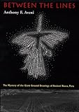
By: The Scribe on Saturday, June 16, 2007

A specialist by the name of David Johnson has done some work of his own on the Nazca lines, and has come up with a theory that is considered somewhat more plausible than some of the previously suggested ideas. Because the region is one of the driest in the world, the Nazca people actually created known underground waterways that made use of some of the excellent reservoirs located below the desert surface.
Through a somewhat controversial method known as dowsing, Johnson tracked the water tunnels, in order to determine whether the areas of the ground around the images contain water or not, and it is his belief that the pictures lie in correlation to water sources. The images were thus created as large-scale maps so that inhabitants of the area could find water, no matter where in the desert they were located. The glyphs themselves were then depictions of water gods, or religious figures that the Nazcans believed to represent each water source.
In 1985, archaeologist Johan Reinhard published a report using archaeological, topographical, ethnographic and historical data to demonstrate that Nazca religion and ritual was greatly centered around the worship of mountains and water sources. It was his belief that the figures were a part of Nazcan religious practices involving crop fertility and water provision, wherein the Nazca lines were used as sacred paths that led to places where each deity could be worshiped. The gods could see the images on the ground that honored them, and thus act benevolently toward the people, knowing they were being venerated. The various figures were thus symbolic of the gods and their attributes, though the specific meaning of each image has yet to be deciphered.
Reinhard’s theory built on the work of Johnson, and has since become the most accepted explanation for the Nazca lines, due to the ethnographic information that compared what archaeologists know of the ancient Nazca people with the modern religious habits and practices of some Andean cultures.

Although Reinhard’s theory is widely understood as the most logical explanation for the Nazca lines, they still present a fascinating visual wonder along the Peruvian coast, and will continue to serve as objects of wonder about this ancient culture and their curious but fascinating drawings on the desert floor.
Want to read more?


Tomorrow: Who’s up for a 2000 year old bowl of fruit salad?
By: The Scribe on Friday, June 15, 2007

Why did the Nazca people make these pictures? It’s a good question, and one that actually hasn’t received a satisfactory answer yet. But for the sake of entertainment, here’s a list of the various theories that have popped up over the past few decades since the lines’ discovery. Who knows…maybe one of these ideas will spark a conspiracy theory of your own!
Maria Reiche (1903-1998): a German mathematician and archaeologist, Reiche believed the Nazca lines were an astronomical calendar that determined planetary events like solstices and when important stars rose. She associated certain drawings with known constellations, and thought the lines could be used as observatories. She completed a lot of work and managed to have the lines declared a World Heritage Site in 1995, though she was never able to prove her own theories.
Erich von Daniken (born 1935): Daniken was the first to suggest seriously that the geometric Nazca lines were built by alien astronauts as a landing strip for their UFOs. His 1968 book, Arrival of the Gods, made the claim that the soft soil and layer of desert rocks were blown away by the spaceships’ rocket propulsion systems, so they left, dissatisfied with the landing space. The people of the area then apparently tried to call the aliens back by drawing their own images in the desert.

Simone Waisbard: Waisbard was also convinced of the lines’ purpose as an astronomical calendar, though she added the idea that the lines were part of a system that could be used to measure precipitation in the area. She thought that some of the figures, such as the seabirds, had a place in Nazcan meteorological prophesy. She also believed that the geometric figures were places for animals to be kept before sacrifice or places for ritual ceremonies of different Nazca clans.
Robert Bast: an Australian author, Bast has suggested that all the plant, animal and human figures lying together randomly on the ground appear like corpses after a catastrophic flood. In his book Memory of the Deluge, Bast explains that the Nazca plateau might be a memorial place of the ‘Big Flood’.
Jim Woodmann: making a balloon out of Peruvian cotton and a reed basket, Woodmann created himself what he thought could be a replica ‘ancient hot-air balloon’, believing this method could have been used to direct the creation of the images… though he didn’t quite explain how the directions could have been communicated to those on the ground. The test flight was nearly fatal for Woodmann, however – without proper equipment, his balloon began to rise too quickly, and both he and his co-pilot barely jumped to safety before the balloon flew off into the desert, uncontrolled!

These are just a few of the theories on the Nazca lines that have developed over the decades… but what do the more recent – and less controversial – archaeologists have to say on the matter?
…to be continued…
Want to read more?

Tomorrow: Okay, probably not really Aliens…
By: The Scribe on Thursday, June 14, 2007
 The Nazca desert stretches for about 80 kilometers along the Pampas de Jumana in Peru, and contains some incredible images that can only be clearly seen and identified when viewed from high in the air. These ‘Nazca lines’ cover this area of desert: there are several hundred very simple geometric patterns and lines across the plateau, and over 70 insect, animal, and human figures with curving lines. Some of the largest figures are around 270 meters long… and have spawned some interesting theories as to their purpose and methods of creation.
It appears that the Nazca lines were created by removing the iron-oxide coated pebbles from the desert surface, causing a contrast between the pebbles and the lightly colored ground underneath. The drawings have actually managed to survive throughout the centuries due to the very little rainfall in the region – only about 20 minutes of rain every year – making this one of the driest places on Earth. With little rain to displace the pebbles, and the extremely flat-lying ground to avoid wind displacement, the lines have remained virtually untouched since their original creation.

Possibly the most pressing questions about these drawings are: why did the Nazca make them, and how did they manage to create such elaborate images if they could only be seen from the air? For anyone on the ground, the drawings simply appear to be random lines of light-colored earth, and nothing lower than several hundred feet in their air would allow someone to even begin to see a complete design on the ground, due to their extensive size.
All ‘whys’ aside, the ‘how’ has seems to have reached an acceptable conclusion: using some simple tools and early surveying equipment, the Nazca planned out their designs and then implemented them using wooden stakes and string lines. Some ceramic pieces found on the desert surface nearby suggest that these were used to displace or collect the gravel being moved – ceramic pottery can be quite durable, though also easily disposed of and replaced when broken. With some careful measuring and basic mapping skills, it has been suggested that a small team of people could create one of the larger figures in a matter of days.
That takes care of the ‘how’… but what about the ‘why’?
…to be continued…
Want to read more?
Tomorrow: It was aliens…obviously!
Previous page | Next page
